
¶ Types of approaches and their specifics
¶ Types of instrument approaches
An IFR flight generally ends with an instrument approach. This is a procedure that allows descent along a track, designed to avoid obstacles, until the point (the minima) at which the visual references will be sufficient to continue the landing manually (with the exception of automatic approaches).
This point is either a decision altitude (or height) (DA/DH), for approaches with vertical guidance, or a missed approach point (MAPT) combined with a minimum descent altitude (MDA), for 2-dimensional (2D) approaches.
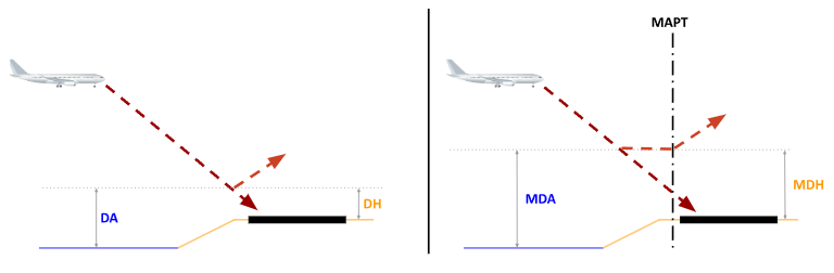
In order to carry out an instrument approach, the weather conditions must be better than those required for the approach speed category in question (from A to E) for the procedure concerned.
Where applicable, the aircraft's technical capabilities must also be compatible (this is the purpose of the RVR/XXX field in the flight plan).
In cases where the approach is not aligned with the runway axis (or even at the threshold opposite the QFU in use), it is followed by a visual procedure, which can be free (then called MVL for Manoeuvre à Vue Libre, circling in English) or prescribed (VPT for Visual with Prescribed Tracks). In this case, the minima are much higher than for a straight-in approach.
Several types of approaches are distinguished according to the means used. They are all described by procedure charts in the country's AIP, and named after the means and the runway served, possibly accompanied by a letter to distinguish them if needed.
¶ ILS approach
The ILS, for Instrument Landing System, is a radio system composed of 2 elements: the Localizer, for lateral guidance, and the Glide-Slope (or simply glide), for vertical guidance. Furthermore, following an ILS approach usually requires a means of verifying altitude in order to detect a possible "false glide" (a dangerous phenomenon related to the reflection of the signal off the ground). This can be a DME (Distance Measuring Equipment, the most common), Marker beacons (outer, middle, inner), or other beacons, VOR bearings, etc.
It is a very widespread radio aid at medium to large airports. It is costly to purchase as well as to maintain, and requires regular calibration flights. On the other hand, it is currently the most accurate aid available.
ILS approaches are classified into categories according to the minima they allow to be achieved, expressed in DH (for Decision Height):
A CAT III certified ILS even allows, for an aircraft also certified with a qualified crew, to carry out an automatic approach with no decision height, meaning the crew only sees the runway once on the ground.
From the controller's point of view, an ILS approach is relatively simple to manage.
If the approach is built with a track from a point (e.g. MOPAR ILS Z 05 at LFPT), it is enough to bring the aircraft in good conditions (notably a 90° max angle) to the point in question so it can begin the procedure.
If localizer interception is done via radar vectoring, the rules to follow are:
- angle between 30 and 45°. Intercepting at too steep an angle carries a risk of overshoot (especially at high speed). Too shallow an angle can cause problems with onboard automation interception logic, so it should also be avoided. Note that the heading you give must take the wind into account at the interception altitude. Example at CDG, if heading 060 allows a fairly comfortable interception of an ILS 08R, this heading may become 050 with a north wind.
- "moderate" speed: approximately 230kts max (again, take the wind into account, which can be very different from the wind on the ground)
- straight and level flight of 30s or 1NM minimum before intercepting the localizer
- interception at the latest 2NM before the descent point on the glide (shown on the radar) at the interception altitude. On this stabilization level segment, if it is not imposed for sequencing reasons, expect the crew to request a speed reduction (200 or even 180kts, particularly on heavy aircraft), in order to extend the drag devices in time.
It is always good to check that the glide has been correctly intercepted. If it is not intercepted, or if the vectoring was carried out too high above the path, the risk is of causing an unstabilized approach, a precursor to a runway excursion. A well-executed missed approach is better than a risky attempt to recapture the path.
¶ LOC, VOR and NDB approach
Used as en-route navigation aids, VOR and NDB can also be used to define an approach. There are also approaches based solely on a LOCalizer, i.e. an ILS without glide. In all these cases, there is no vertical guidance: it is the crew who calculates a descent path and follows it down to a minimum altitude, the MDA (Minimum Descent Altitude). If the runway is in sight before the MAPT (Missed Approach PoinT), the landing continues; otherwise the crew will follow the published missed approach procedure.
As with an ILS, monitoring the descent path can be made easier by the presence of a DME, whether or not it is co-located with the beacon serving as the basis for the approach itself.
The LOC has, by definition, the same lateral accuracy as an ILS. VOR accuracy is lower, and NDB accuracy is lower still. Consequently, track-following can be noticeably worse, and the minima are higher.
For the controller, these approaches are generally defined via a track from a point, hence fewer radar vectoring possibilities. Furthermore, following a constant descent path without vertical guidance requires configuring the aircraft at approach speed before starting the descent. This is an aspect to take into account in the case of a sequence of several aircraft, especially if their performance is disparate.
Finally, on these 2D approaches, the QNH is a critical element. An incorrect QNH on board will cause a shift in the descent path, either upward, with the risk of not breaking through the cloud layer and/or ending up too high relative to the runway, or downward, with the risk of CFIT (Controlled Flight Into Terrain).
There is no way to detect this error on board, other than possibly the E-GPWS. It is therefore essential to:
- check that the crew reads back the correct QNH at the moment it is given by ATC
- check that the altitude reported by mode C does indeed match the one expected during the level segment before starting the descent.
¶ RNP approach
The improvement in onboard navigation system performance now allows the construction of approaches without any ground-based radio aid, and therefore much less costly and relatively easy to deploy. They are found increasingly often at all types of aerodromes, including minor ones without regular commercial traffic.
To follow an RNP approach (for Required Navigation Performance), an aircraft must be equipped and certified accordingly: navigation accuracy must be ±0.3NM 95% of the time, and onboard systems must continuously monitor this accuracy and alert the crew in case of a failure.
An RNP approach can be built either with a full track from a given point, or with only a final approach axis. In the first case, ATC must send the aircraft direct to the point with an angle of less than 90° relative to the following segment.
In the second, the recommendations are the same as for intercepting an ILS, generally with a direct to the IF (Intermediate Fix), or a heading if the aircraft is equipped with Vectors To Final (VTF). Simplicity will generally dictate vectoring toward the IF so as not to have to query each aircraft on this point.
The same RNP approach can be used with 3 different types of minima, from least to most precise:
- LNAV: only lateral guidance is used. The accuracy is constant (0.3NM). The path is calculated by the crew as with the 2D approaches described above. Consequently, the descent will most often be started with the aircraft configured at approach speed, and the QNH is of critical importance.
- LNAV/VNAV: the aircraft provides vertical guidance which is most often based on barometric altitude. Consequently, here too, a QNH error will have potentially catastrophic consequences. The accuracy is constant (0.3NM and 75ft)
- LPV (Localizer Performance with Vertical guidance): vertical guidance follows a path geometrically constructed by the onboard systems (FMS/FMC), and whose accuracy is angular, becoming finer as the aircraft gets closer to the runway.
It should be noted that, contrary to what one might think, the vast majority of airliners are NOT LPV-equipped but only LNAV/VNAV, whereas general and business aviation are more often equipped with it.
If all 3 types of minima are published for a given approach, ATC has no say over which minima the crew will use. It will simply provide guidance toward the RNP XX procedure.
Unlike an ILS, whose signal exists within the physical limits of wave propagation and allows for path recapture, an RNP approach does not necessarily allow for such recovery. Consequently, if the aircraft is vectored above the interception altitude at the FAF, the only possible outcome is an interruption of the approach and new vectoring.
¶ Other approaches
There are other types of instrument approaches, but you will not encounter them in the context of civil control in France. They are mentioned here for informational purposes only (and even more obscure ones are left to the curious reader!).
- PAR (Precision Approach Radar): azimuth and elevation information is given verbally by a controller dedicated to this task, using a precision radar. This approach is usually only found at military or joint-use airfields.
- MLS (Microwave Landing System): supposed to allow curved approaches with an accuracy similar to the ILS, this system is rarely found outside the USA.
- TACAN (TACtical Air Navigation): a military beacon working in a way very similar to a VOR, usually paired with a DME, which allows the creation of 2D approaches. Requires a specific onboard receiver.
- LP: an LPV approach without vertical guidance.