
¶ Radar identification and how radar works
¶ Radar identification
Radar identification is an operation that consists of making sure that the aircraft calling is indeed the one the controller observes on radar. In other words, it is a simple operation aimed at obtaining a correlation between the radar picture and the aircraft's actual position.
This procedure is necessary before beginning any radar service with the aircraft in question.
Before understanding how this operation is implemented in practice, let's briefly look at how a radar works.
¶ Correlation
A radar only serves to display the aircraft's position. It has no knowledge of the aircraft's other information (flight plan, etc.). Correlation is the act of matching the information returned by radar antennas (primary and secondary) with the computer information known about an aircraft (flight plan). Depending on the aircraft's transponder, the correct flight plan can be linked to the correct radar plot.
¶ A controller's radar: how does it work?
Before discussing an aircraft radar, let's take the example of a speed-control radar on a highway. From a physical standpoint, an electromagnetic wave is sent from the radar toward the car, which here is the target. The wave is then "reflected" and returns to the radar. The physical principle at the heart of this process is the Doppler effect.
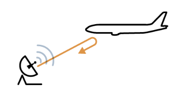
Le radar du contrôleur aérien est basé sur le même principe physique. Il convient juste de faire la différence entre 2 types de radar : le radar primaire et le radar secondaire.
¶ Primary radar (Primary Surveillance Radar)
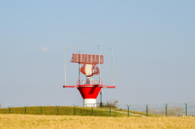
This is the radar based on the principle we have just seen. It is easily recognizable by its red antenna and its fast 360° sweep.
¶ Secondary radar (Secondary Surveillance Radar)
The origin of the SSR dates back to the Second World War. It was developed by the Allies based on the "friend or foe" identification principle (Identification Friend or Foe). Greatly improved since then, secondary radar is still used today. It is in fact thanks to this radar that transponder families came into being.
Secondary radar, for its part, transmits an interrogation request. When it is received by the aircraft's transponder, the transponder responds by returning various pieces of information depending on its transponder type.
If the aircraft's transponder is switched off, it will not respond to the interrogation, and the controller will therefore not see it on their radar screen. The remaining parameters are calculated by the radar through electronic processing so that they can then be displayed on the controller's screen.
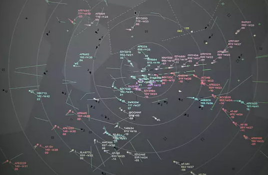
Above is the radar view of LFPG_APP (Credits: AirTeamImages).
For more information on the transponder, see the dedicated sheet: Transponder.
¶ Identification methods
Radar identification is a procedure used by "Approach" (APP) and "Centre" (CTR) control positions. In real life, you will sometimes hear "Tower" (TWR) positions perform identification: these are very specific cases. Consider that on VATSIM, in France, only APP and CTR positions are concerned by radar identification.
On VATSIM, there are two radar identification methods, namely:
- Transponder identification
- Use of the position report principle
¶ Transponder identification
¶ From the aircraft's label
When the traffic transmits on your frequency at first contact, you have several actions to carry out:
- Make sure the callsign announced by the pilot matches the one on the label.
- Check the aircraft's current altitude or flight level.
- Check that there is no alert at the transponder level (DUPE or other code)
- Check the traffic's current heading or next route point.
If all these elements are consistent, the aircraft is identified.
Example of a correctly identified traffic:
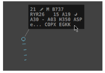
In the example above, we identify "Ryanair 26", altitude 3000 feet, assigned heading 350°.
If one of the 4 preceding parameters is not consistent, you as the controller must make sure that what the radar shows you does indeed reflect reality (see next part - Use of position report).
Example of an unidentified traffic:
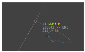
In the example above, "Alpine 642" needs a new transponder code.
¶ By asking the pilot to squawk "IDENT"
If it is not possible to identify the aircraft with certainty, you can ask the pilot to use the "IDENT" function of the transponder. The label should then blink and it will be easier for you to identify the aircraft.
¶ Use of position report
In cases where one of the identification parameters is not consistent, it may be wise to use the position report in order to make sure the radar picture is consistent. This solution also indirectly makes it possible to make sure the pilot is following the requested route in the appropriate configuration.
AFR1580: Nice Approach hello, AFR1580, level 250, route ABLAK.
The pilot appears at level 275 on the radar: the flight level is not consistent. The pilot probably does not have the QNH set to "Standard" (STD).
LFMN_APP: AFR1580, Nice Approach hello, confirm level 250 at standard QNH 1013 hPa?
Wait a few seconds until the radar picture becomes consistent
LFMN_APP: AFR1580, Nice Approach, identified level 250